เรื่องนี้เป็นประสบการณ์จริงของผู้เขียนเองค่ะ และเชื่อว่าจะเป็นประโยชน์กับเจ้าของที่ดินทุกคน โดยเฉพาะคนที่กำลังประกาศขายที่ดินอยู่
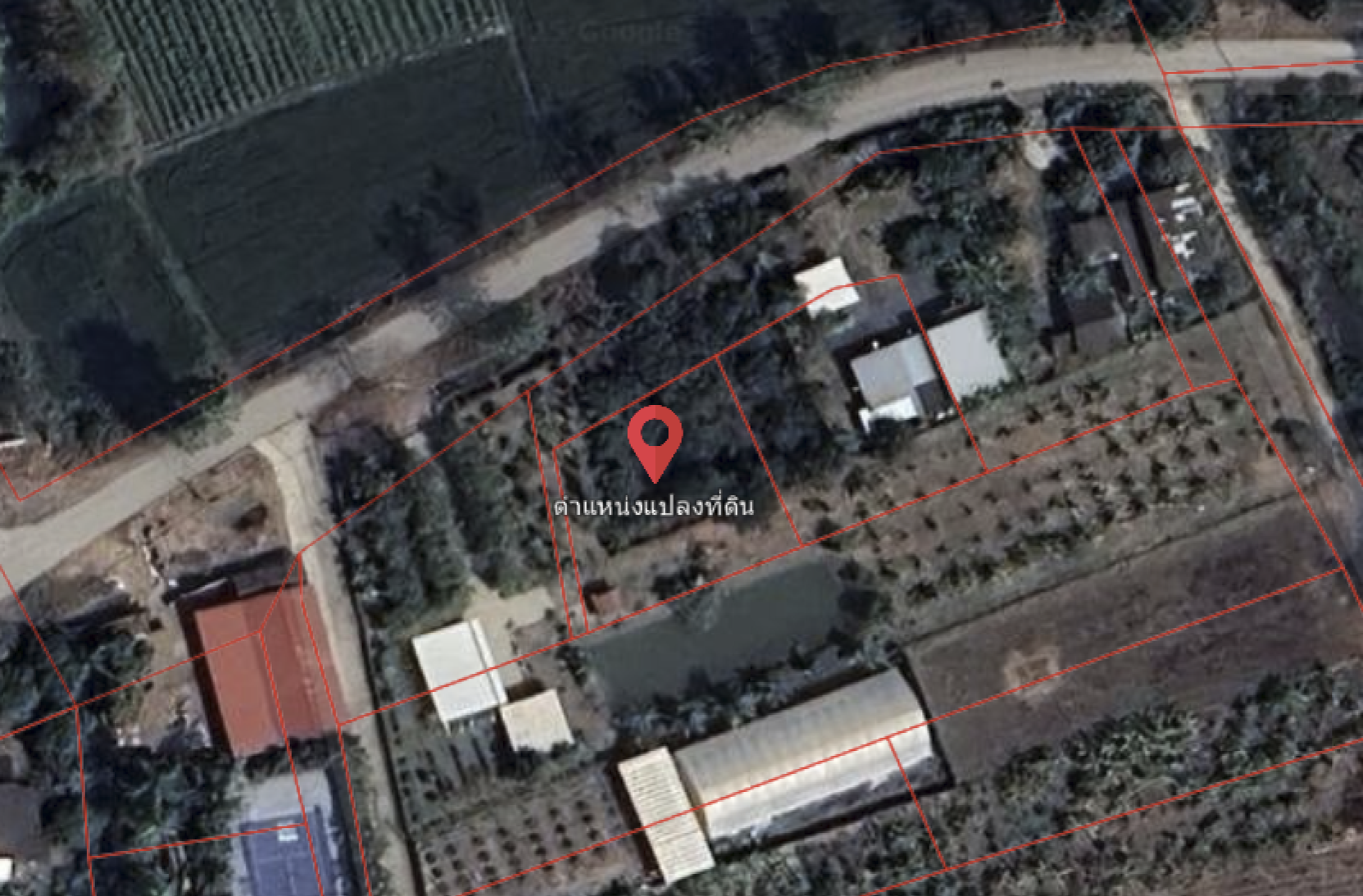
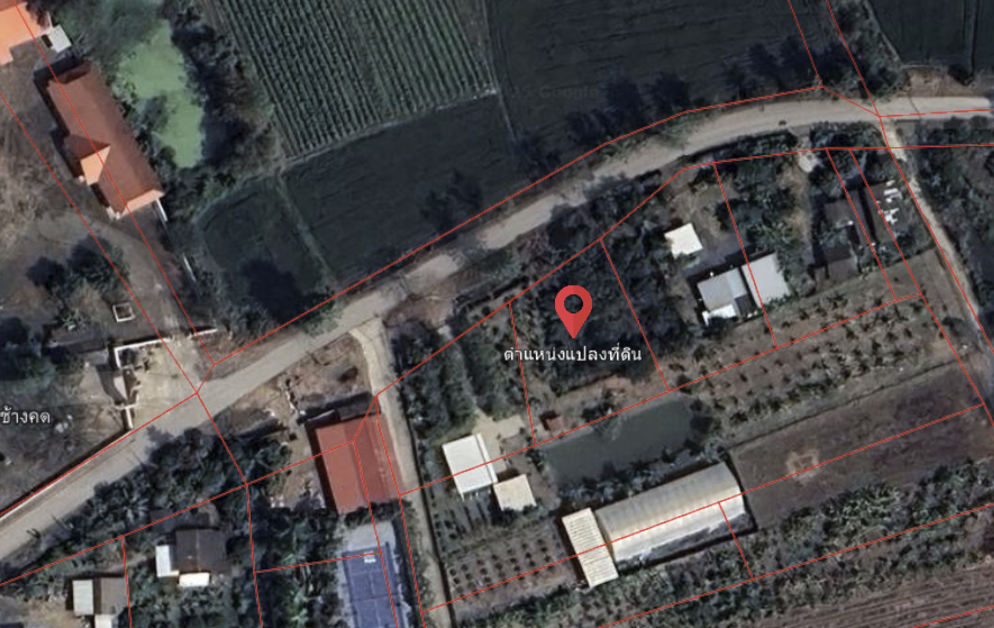
ผู้เขียนมีที่ดินแปลงหนึ่ง ในโฉนดติดถนนสาธารณะ และพื้นที่จริงก็ติดถนน รถเข้าออกได้ปกติ
จึงประกาศขายไว้ โดยไม่ได้คิดจะเข้าไปตรวจสอบรูปแปลงในระบบออนไลน์
เพราะในโฉนดมันคือที่ดินติดทางสาธารณะ และมีถนนชัดเจนมาก
จนกระทั่งวันหนึ่ง มีผู้สนใจโทรมาสอบถามว่า
“ทำไมผมเช็คในเว็บแล้ว ที่ดินแปลงนี้ไม่ติดทางออก เหมือนเป็นที่ดินตาบอด”
ตอนนั้นยอมรับว่าแปลกใจ เพราะความเป็นจริงที่ดินไม่ได้เป็นที่ดินตาบอด
ผู้สนใจแจ้งว่าเขาเช็คจากเว็บไซต์ LandsMaps ของกรมที่ดิน ผู้เขียนจึงเข้าไปตรวจสอบด้วยตัวเอง
และสิ่งที่เห็นทำให้ตกใจ ในระบบแสดงผลว่า
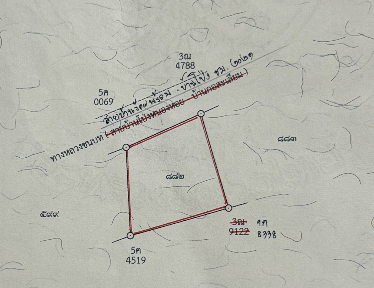
แปลงที่ดินของเราไม่มีทางออกติดถนน
รูปแปลงในเว็บดูเหมือนถูกกั้นด้วยแปลงที่ดินข้างเคียง
และกลายเป็น ที่ดินตาบอด ในสายตาของผู้ซื้อทันที
หลังจากนั้น จึงติดต่อไปที่เพจกรมที่ดิน
เพื่อสอบถามว่าเหตุใดข้อมูลจึงแสดงแบบนั้น
ทางเพจให้เบอร์ติดต่อเจ้าหน้าที่ผู้ดูแลระบบ LandsMaps
เมื่อโทรสอบถาม เจ้าหน้าที่แจ้งว่า
ระบบ LandsMaps รับข้อมูลมาจากฐานข้อมูลกรมที่ดิน
ทางผู้ดูแลระบบไม่สามารถแก้ไขข้อมูลให้ได้โดยตรง
หากข้อมูลคลาดเคลื่อน ต้องติดต่อสำนักงานที่ดินตามที่ตั้งโฉนดเท่านั้น
จึงได้นำ สำเนาโฉนดที่ดิน
ไปติดต่อสำนักงานที่ดินตามพื้นที่ที่ตั้งโฉนด โดยติดต่อ แผนกรังวัด โดยตรง
เมื่อยื่นเรื่อง เจ้าหน้าที่ก็ทำการตรวจสอบข้อมูล และดำเนินการแก้ไขรูปแปลงในระบบฐานข้อมูล
ระยะเวลาดำเนินการประมาณ 2–3 วันทำการ
หลังจากนั้น ผู้เขียนเข้าไปเช็คในเว็บไซต์ LandsMaps อีกครั้ง
พบว่ารูปแปลงที่ดินได้ถูกแก้ไขให้ตรงกับโฉนดเรียบร้อยแล้ว
จากที่เคยแสดงเป็นที่ดินตาบอด ก็กลับมาแสดงว่าติดถนนถูกต้องค่ะ
จากเหตุการณ์นี้ ข้อแนะนำถึงเจ้าของที่ดินทุกคน
หากคุณมีที่ดิน ไม่ว่าจะประกาศขายหรือยังไม่ขาย
แนะนำให้เข้าไปตรวจสอบรูปแปลงในเว็บไซต์ LandsMaps ทันที เพราะข้อมูลที่แสดงในระบบ
อาจส่งผลต่อความเชื่อมั่นของผู้ซื้อโดยตรง และถ้าพบว่ารูปแปลงคลาดเคลื่อน
รีบติดต่อสำนักงานที่ดินพร้อมสำเนาโฉนด
เพื่อดำเนินการแก้ไขให้ถูกต้อง
เพราะอาจกลายเป็นปัจจัยใหญ่ในการตัดสินใจซื้อขายที่ดิน
ถ้าใครยังไม่เคยเช็ค
เข้าไปตรวจสอบด่วนเลยค่ะ
อ่านบทความแนะนำระบบตรวจสอบที่ดิน ผ่านระบบของทางราชการ
ที่ลิ้งค์นี้ค่ะ https://chiangmaipropertyhub.com/th/articles/landsmaps
This story is based on the author’s real experience and is believed to be beneficial to all landowners, especially those who are currently listing land for sale.
The starting point was confidence that the land “definitely had road access.” The author owns a parcel of land that, according to the title deed, is adjacent to a public road.
In reality, the land also borders the road and vehicles can enter and exit normally.
It was therefore listed for sale without considering checking the plot layout in any online system.
Because in our understanding, it was clearly road-adjacent land.
Until one day, an interested buyer called to ask,
“Why does it show on the website that this land plot has no access road? It looks like landlocked land.”
At that time, I admit I was surprised, because in reality the land was not landlocked.
The interested buyer said he checked from the Department of Lands’ LandsMaps website. The author then went to check personally,
and what appeared was shocking. In the system it showed that
our land plot “had no road access.”
The plot shape on the website looked as if it was blocked by neighboring land parcels.
And it immediately became “landlocked land” in the eyes of buyers.
But the image in the online system clearly created misunderstanding.
After that, I contacted the Department of Lands’ page
to ask why the data was displayed that way.
The page provided a contact number for the officer responsible for the LandsMaps system.
When calling to inquire, the officer informed that
the LandsMaps system receives data from the Department of Lands database.
The system administrator cannot directly correct the data.
If the information is inaccurate, the landowner must contact the Land Office where the title deed is registered.
Therefore, I brought a copy of the land title deed
to contact the Land Office in the area where the title deed is located, contacting the Survey Division directly.
After submitting the request, the officer checked the information and proceeded to correct the parcel layout in the database system.
The processing time was approximately 2–3 business days.
After that, the author checked the LandsMaps website again
and found that the land parcel layout had been corrected to match the title deed properly.
From previously being shown as landlocked, it was displayed correctly as having road access.
From this incident,
do not assume that if the physical land has road access, the online system will always be correct.
Modern buyers check information through LandsMaps before making a decision.
If the system data is incorrect, it may cause you to lose a sales opportunity without realizing it.
Corrections can be made, but they must be handled at the Land Office only.
Advice to all landowners:
If you own land, whether you are selling it or not,
It is recommended to immediately check the parcel layout on the LandsMaps website, because the information displayed in the system
may directly affect buyer confidence, and if you find that the parcel layout is inaccurate,
contact the Land Office with a copy of the title deed
to proceed with correction as soon as possible.
Because it may become a major factor in the decision to buy or sell land.
If you have never checked,
go and verify it urgently.